


Introduction to our
Watershed

a partnership between the City of Chattanooga Stormwater Division & Chattanooga State
Protecting NATURE’S resource through knowledge and
awareness of our Watershed

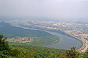
The Lower Tennessee River Watershed is located in the states of Tennessee, Alabama and Georgia. Parts of
nine East Tennessee counties make-up the Tennessee section of the Lower Watershed. Those nine counties
are: Hamilton, Rhea, Meigs, Bledsoe, McMinn, Sequatchie, Roane, Bradley, and Loudon. The Lower Tennessee
River Watershed drains approximately 1870 square miles of area with 1201 square miles being in Tennessee.
From those 1201square miles approximately 1503 stream miles wind through nature as the watershed’s
run-off makes it’s way through the Tennessee Valley. The State of Tennessee boasts of nearly 45,780 lake acres
of which most is pooled in the Chickamauga Lake named in honor of the Chickamauga tribe of native Americans
that broke away from the larger Cherokee Nation that called the region home.
The Lower Tennessee River Watershed is made up of approximately 15 Land Use regions. The regions are:
Low Intensity Residential, High Intensity Residential, High Intensity Commercial, Evergreen Forest, Emergent
Herbaceous Wetlands, Deciduous Forest, Bare Rock/Sand/Clay, Woody Wetlands, Transitional, Row Crops,
Quarries/Strip Mines/Gravel Pits, Pasture/Hay, Other Grasses, Open Water, and Mixed Forest. The largest
regions equaling nearly 42% of the entire Lower Watershed is the Deciduous Forest.
The Lower Tennessee River Watershed is a complex system of natural systems that make-up an integral
part of the area where we live, work and play.
Source: www.tennessee.gov/.../watersheds/.../lowertn/lowertn2.pdf
